Introduction
Hurricane Erin has strengthened once again in the Atlantic Ocean, sparking widespread concern across coastal communities and international weather agencies. Meteorologists are warning that the storm, now a powerful Category 2 hurricane, could continue to intensify over the next several days. With sustained winds of 105 mph and the potential for further strengthening, Erin has become one of the most closely monitored tropical systems of the 2025 Atlantic hurricane season.This article provides the latest information, detailed forecasts, preparedness tips, and expert insights into Hurricane Erin’s development. If you are searching for updates on Hurricane Erin 2025, its path, impacts, and safety recommendations, you are in the right place.
Current Status of Hurricane Erin
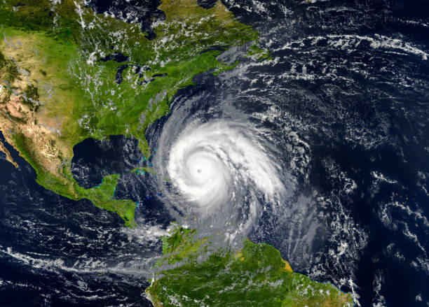
As of this morning’s update from the National Hurricane Center (NHC), Hurricane Erin is currently:- Location: Several hundred miles east of the Bahamas, moving northwest at 12 mph.
- Maximum sustained winds: 105 mph, with stronger gusts reported near the eyewall.
- Category: 2 on the Saffir-Simpson Hurricane Wind Scale.
- Central Pressure: Estimated at 976 mb, which indicates continued strengthening.
Satellite imagery shows a well-defined eye, strong convection around the center, and spiral rain bands stretching outward for hundreds of miles. These signs suggest that Erin has favorable environmental conditions for further intensification as it tracks across the Atlantic.
Why Did Hurricane Erin Strengthen Again?
Hurricane Erin initially weakened slightly earlier in the week, but it regained intensity due to:1. Warm Atlantic Waters: Sea surface temperatures remain above average, providing ample energy for the storm.
2. Low Wind Shear: The absence of strong upper-level winds has allowed Erin’s core circulation to remain intact.
3. Moist Atmosphere: High humidity in the mid-levels of the atmosphere is fueling strong thunderstorm activity.
These three factors create the perfect recipe for a hurricane to strengthen quickly, and forecasters are monitoring whether Erin could intensify further into a Category 3 major hurricane within the next 24 to 48 hours.
Potential Impacts of Hurricane Erin
Although Erin is currently out at sea, its growing strength means potential hazards for coastal regions. Here are the main risks:- Dangerous Surf and Rip Currents: Even if Erin does not make direct landfall, powerful waves and rip currents are expected along the U.S. East Coast, the Bahamas, and parts of the Caribbean.
- Heavy Rainfall: Outer rain bands could cause localized flooding in islands near Erin’s path.
- Strong Winds: If Erin continues strengthening, winds may extend far from the center, impacting shipping routes and small islands.
- Storm Surge: In the event of a closer landfall scenario, low-lying coastal areas could face life-threatening storm surge.
Hurricane Erin’s Forecast Track
According to the latest NHC forecast cone, Hurricane Erin is projected to continue on a northwestward path over the next few days. While the majority of forecast models suggest Erin may remain offshore, there is still uncertainty. A slight shift westward could bring the storm closer to the U.S. East Coast, particularly Florida, Georgia, and the Carolinas.Meteorologists emphasize that long-range forecasts can change quickly, and residents across the southeastern U.S. should remain on high alert.
How This Compares to Past Hurricanes
The Atlantic hurricane season has already produced multiple storms this year, but Erin stands out due to its pattern of weakening and restrengthening. Experts note that this is not unusual, as hurricanes often fluctuate in strength depending on environmental factors.For example, in previous years, hurricanes like Florence (2018) and Dorian (2019) underwent periods of weakening before rapidly intensifying again. Hurricane Erin appears to be following a similar trajectory, raising concerns about its long-term strength.
Preparedness Tips for Residents
Even if Hurricane Erin does not make landfall, preparedness is crucial during hurricane season. Here are steps recommended by emergency management experts:- Stay Informed: Follow updates from the National Hurricane Center, local authorities, and trusted weather outlets.
- Prepare Emergency Kits: Include food, water, flashlights, medications, and important documents.
- Secure Property: Reinforce windows, clear outdoor debris, and check roofing.
- Evacuation Plans: Know your evacuation zone and have a plan for where to go if ordered to leave.
Authorities Issue Warnings
Emergency officials caution that hurricanes can shift paths unexpectedly. Even if Erin stays offshore, its large wind field and dangerous surf will still pose hazards. Coastal communities are urged to prepare for:- Flooding from heavy rainfall.
- Power outages due to strong winds.
- Transportation delays from rough seas and flight disruptions.